Neutral weather pattern expected to resume
While the La Niña weather pattern has extended for longer than expected, neutral weather conditions are expected to resume as autumn takes hold – bringing good news for producers. Read on to find out the latest on the weather outlook for 2022.
IOD
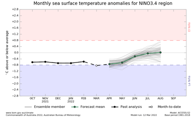
Figure 1: the forecast for a neutral Indian Ocean Dipole (IOD). Source: Bureau of Meteorology.
The Indian Ocean Dipole (IOD) is the difference in sea surface temperature between the two poles. A negative IOD is associated with a La Niña event and often brings more rain to Australia, especially in the Northern Territory and southern Australia.
The Bureau of Meteorology (BOM) predicts that there will be a neutral IOD for the rest of autumn. In recent years, there has been a trend towards higher intensity but shorter rainfall events in Australia.
La Niña
La Niña has extended for longer than expected with stronger than average trade winds. This often increases the likelihood of above average rainfall and tropical cyclones during autumn. Even though La Niña is past its break point, atmospheric and oceanic indicators are remaining at La Niña levels.
These conditions are expected to ease over the next few months. The latest BOM outlook indicates that there will be a return to the neutral El Niño–Southern Oscillation (ENSO) weather pattern –the pattern that is neither La Niña or Il Niño. Six out of seven models created by BOM predict a neutral ENSO by June. There is also an indication of above average cloud cover and rainfall across northern Australia.
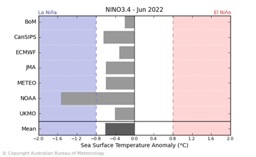
Figure 2: indicators showing a strong neutral ENSO. Source: Bureau of Meteorology.
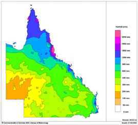
National rainfall
Large rainfall events have been experienced on the east coast of Australia over the last three months. The NT has experienced high rainfall in the north of the state associated with their wet season. Patchy rainfall across the rest of the state at the beginning of the year has bought in lower than average rainfall.
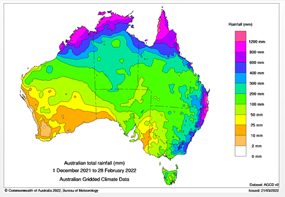
Figure 3: national total rainfall over the last three months. Source: Bureau of Meteorology.
 |
 |
 |
 |
Figure 4: rainfall comparisons by state year-on-year, 2022 to 2021. Source: Bureau of Meteorology.
In general, there has been higher yearly rainfall experienced, especially in the Northern Territory and Queensland year-on-year with La Niña coming to an end as autumn begins.
|
|
January 2021 |
February 2021 |
March 2021 |
January 2022 |
February 2022 |
March 2022 |
|
Wagga Wagga |
69.8mm |
112.8mm |
117.2mm |
103.4mm |
16.6mm |
32.8mm |
|
Roma |
77.2mm |
68.6mm |
134.4mm |
15mm |
71.6mm |
3.4mm |
|
Dubbo |
54mm |
114.4mm |
187.2mm |
130mm |
41mm |
42.6mm |
|
Ballarat |
117.8mm |
10.2mm |
55.6mm |
66mm |
0.2mm |
42.2mm |
|
Katanning |
4.8mm |
40mm |
24mm |
2mm |
3.2mm |
19mm |
|
Tennant Creek |
86.4mm |
60.4mm |
9.6mm |
156.4mm |
10.2mm |
0.0mm |
Table 1: Comparison of total rainfall over three months year-on-year.
There have been lower rainfalls year-on-year across Australia between January and March especially in areas around Roma, Ballarat, Katanning and Tennant Creek. This reflects the movement towards a neutral ENSO. The increase in shorter periods of heavier rainfall would reduce monthly total rainfall.
Future outlook
Recent weeks have seen lower rainfall in the NT, pushing producers to move cattle early. This could continue as we move further into the dry season, with below average rainfall predicted for large areas of the NT.
For mixed farming areas, high grain prices and favourable predicted weather conditions may cause a change in resource allocations. Other external factors may impact decision making around this as we move further into autumn.